Rohini Bugyal, Uttarakhand – Explore a Beautiful Himalayan Meadow
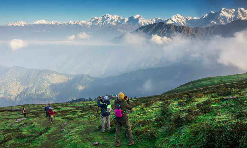
Hidden among the beautiful forests of the Garhwal Himalayas, Rohini Bugyal is a peaceful mountain meadow in the Chopta region of Uttarakhand. Surrounded by dense rhododendron and maple forests, this scenic destination is known for its open green landscapes, mountain views, colourful spring flowers and tranquil natural surroundings.
Rohini Bugyal lies along the popular Deoria Tal–Chandrashila trekking route and is an important stop on the trail from Deoria Tal towards Syalmi and the Chopta region. Unlike easily accessible tourist destinations, reaching this meadow involves exploring forest trails and walking through the beautiful Himalayan wilderness.
The meadow is particularly attractive during spring, when rhododendron flowers add shades of red and pink to the surrounding forests. Its peaceful atmosphere, birdlife and mountain scenery make Rohini Bugyal an interesting destination for trekkers, nature lovers, photographers and adventure enthusiasts.
Where is Rohini Bugyal Located?
Rohini Bugyal is located in the Garhwal Himalayas of Uttarakhand, in the wider Chopta region of Rudraprayag district. It lies along the trekking route connecting Deoria Tal with Syalmi and the Chopta side.
The meadow is surrounded by forested mountain slopes, particularly rhododendron and maple woodland. It forms part of the natural landscape of the Kedarnath Wildlife Sanctuary.
Sari village is an important starting point for visitors exploring the Deoria Tal–Chandrashila trekking circuit. From Sari, trekkers first reach Deoria Tal and can then continue along the longer forest trail towards Rohini Bugyal and Syalmi.
There is no regular motorable road directly to Rohini Bugyal. Visitors need to reach the meadow on foot as part of a trekking route.
Why is Rohini Bugyal Famous?
Rohini Bugyal is known for its peaceful meadow landscape, beautiful forests, seasonal rhododendron flowers and scenic Himalayan views. It is a popular stop for trekkers exploring the Deoria Tal–Chandrashila route.
- Beautiful Himalayan Meadow: The open grassy landscape offers a peaceful break from the surrounding dense forests.
- Rhododendron Forests: The surrounding forest trails become especially colourful during the spring flowering season.
- Mountain Views: The area offers views towards Himalayan peaks, including Kedar Dome and Chaukhamba from suitable clearings.
- Trekking Destination: Rohini Bugyal lies on the Deoria Tal to Syalmi trekking route.
- Birdwatching: Its forest surroundings provide opportunities to observe Himalayan birds.
- Peaceful Natural Environment: The meadow is away from busy roads and crowded tourist areas.
Natural Beauty of Rohini Bugyal
The natural beauty of Rohini Bugyal comes from its combination of open grassy meadows and dense Himalayan forests. The meadow creates a beautiful contrast with the surrounding trees and mountain slopes.
During the warmer months, the open areas become greener and offer a refreshing place for trekkers to rest and enjoy the scenery. Forest trails around the meadow provide beautiful views of the changing landscape.
The surrounding region is particularly attractive to travellers who enjoy quiet mountain environments and prefer exploring destinations on foot rather than visiting crowded tourist spots.
Rhododendron Flowers at Rohini Bugyal
One of the most beautiful features of the Rohini Bugyal trekking route is its rhododendron forest. During the spring flowering season, these trees produce vibrant red and pink flowers that transform the forest trail into a colourful Himalayan landscape.
March and April are particularly attractive months for experiencing the rhododendron bloom, although flowering dates depend on weather and altitude.
The colourful flowers, green forest surroundings and open meadow make this area especially appealing to landscape photographers and nature lovers.
Visitors should avoid picking flowers or damaging plants and should enjoy the forest without disturbing its natural environment.
Views of Kedar Dome and Chaukhamba
Rohini Bugyal offers beautiful mountain scenery along the trekking route. From suitable open sections and forest clearings, trekkers may enjoy views towards Kedar Dome, Chaukhamba and other Himalayan peaks.
The mountain views change according to the trail location, weather and visibility. On clear days, the surrounding ridges and distant snow-covered peaks create a memorable backdrop for the meadow.
The peaceful atmosphere and natural setting make Rohini Bugyal a rewarding place to pause during a longer Himalayan trek.
Rohini Bugyal Trek – Deoria Tal to Syalmi
Rohini Bugyal is best explored as part of the Deoria Tal–Chandrashila trekking circuit. The trail passes through forested slopes and beautiful mountain landscapes before reaching the meadow.
The Uttarakhand Tourism itinerary includes a trekking section from Deoria Tal to Syalmi via Rohini Bugyal. The route is approximately 10 kilometres and generally takes around 6 to 7 hours, depending on pace, weather and trail conditions.
Popular Trekking Route
The broader trekking route can be planned as:
Sari Village → Deoria Tal → Rohini Bugyal → Syalmi → Baniya Kund → Chopta
This is a multi-day trekking route rather than a simple roadside excursion. Trekkers should arrange suitable accommodation or authorised camping arrangements, food, local guidance and transport logistics before starting.
Deoria Tal to Rohini Bugyal
After exploring Deoria Tal, trekkers can continue along the forest trail towards Rohini Bugyal. This section passes through beautiful woodland, including rhododendron and maple trees.
As the trail progresses, the forest opens into meadow sections where visitors can enjoy the surrounding mountain scenery.
Rohini Bugyal to Syalmi
After crossing Rohini Bugyal, the route continues towards Syalmi. The landscape includes forest trails, mountain slopes and open sections along the trekking route.
Syalmi is an important stop on the longer Deoria Tal–Chandrashila itinerary and is used as an overnight halt by organised trekking groups.
Trek Distance, Duration and Difficulty
The following details refer to the official Deoria Tal–Syalmi trekking section that passes through Rohini Bugyal.
- Region: Chopta, Rudraprayag, Uttarakhand
- Route: Deoria Tal – Rohini Bugyal – Syalmi
- Trek Distance: Approximately 10 kilometres for the complete Deoria Tal–Syalmi section
- Typical Duration: Around 6–7 hours for this section
- Terrain: Forest trails, meadow sections and mountain paths
- Difficulty: Moderate as part of the longer trekking route
- Starting Access Point: Sari village via Deoria Tal
The actual walking distance to the meadow depends on the route and starting point. Visitors should not treat the entire 10-kilometre Deoria Tal–Syalmi section as the distance from Deoria Tal to Rohini Bugyal alone.
Birdwatching Around Rohini Bugyal
The forests around Rohini Bugyal provide a suitable habitat for several Himalayan bird species. The combination of forest cover, open clearings and mountain vegetation makes the region interesting for birdwatchers.
Visitors may look out for forest birds and other Himalayan species along the trekking route. Bird activity varies according to season, weather and habitat.
Early morning can be a rewarding time for birdwatching. Carry binoculars, keep noise to a minimum and avoid disturbing nesting or feeding birds.
Camping Near Rohini Bugyal
Rohini Bugyal has been known as a scenic stop for trekkers exploring the Deoria Tal–Chandrashila route. Its meadow setting and forest surroundings make the wider area attractive for outdoor experiences.
However, camping directly on the meadow should not be assumed to be permitted. Forest and meadow conservation rules may restrict overnight stays and camping locations.
Before planning an overnight trek, confirm the current camping regulations, designated sites and required permissions with the Forest Department or an authorised local trekking operator.
Use only approved camping locations, avoid lighting fires in forest areas and carry all waste back with you.
Best Time to Visit Rohini Bugyal
Rohini Bugyal can be explored during different seasons, but spring, summer and autumn offer different natural experiences.
- March to April: Rhododendron forests begin flowering, creating beautiful red and pink landscapes along the trail. Snow may still remain on some higher sections.
- May to June: Pleasant weather and greener meadows make this a popular period for trekking and nature exploration.
- July to August: The landscape becomes lush and green, but monsoon rain can make forest trails slippery and difficult.
- September to October: Clearer weather and autumn scenery make this an attractive period for longer Himalayan treks.
- November to February: Cold weather and possible snowfall can make the route difficult. Winter access should be checked locally before planning a trek.
For travellers interested in rhododendron flowers, spring is particularly attractive. For longer trekking journeys, choose a suitable weather window and confirm the trail conditions before departure.
How to Reach Rohini Bugyal
By Road
Rohini Bugyal does not have direct road access. Visitors first need to reach Sari village, which is the main starting point for the Deoria Tal trek.
A common road route from Rishikesh is:
Rishikesh → Devprayag → Srinagar → Rudraprayag → Agastmuni → Ukhimath → Sari Village.
From Sari, trekkers walk uphill to Deoria Tal and continue on the forest trail towards Rohini Bugyal and Syalmi.
By Train
Rishikesh is one of the nearest major railway stations for travellers heading towards Sari village. From Rishikesh, visitors can continue by bus or taxi towards Rudraprayag and Ukhimath.
By Air
Jolly Grant Airport in Dehradun is the nearest major airport for most visitors travelling to the Chopta and Deoria Tal region. From the airport, travellers can continue by road towards Rishikesh, Ukhimath and Sari village.
Places to Visit Near Rohini Bugyal
Rohini Bugyal is surrounded by several beautiful destinations along the Deoria Tal–Chandrashila trekking circuit. Visitors can include these places in a wider travel plan.
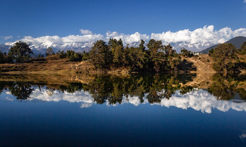
- Deoria Tal: A beautiful Himalayan lake near Sari village, famous for its reflection of the Chaukhamba mountain range.
- Chopta: A scenic mountain destination known for its meadows, forests and Himalayan trekking routes.
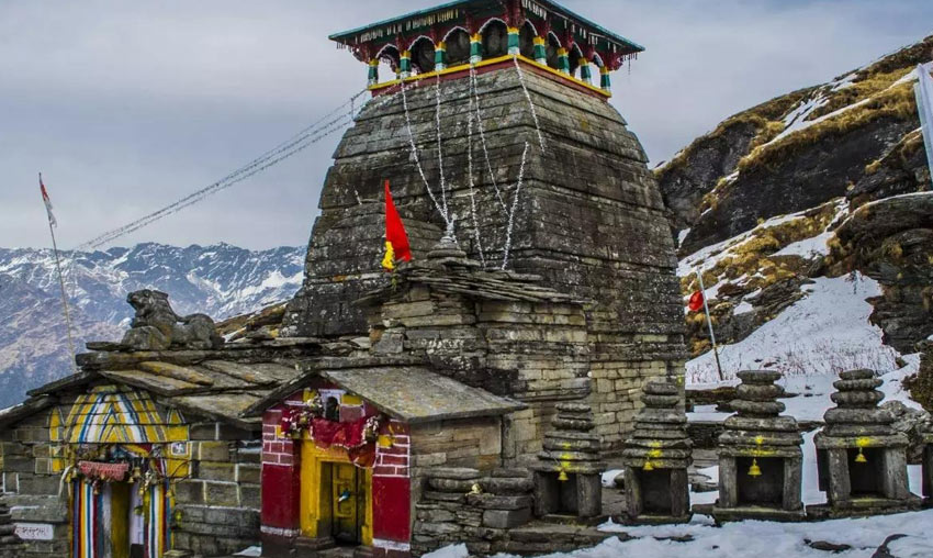
- Tungnath Temple: One of the sacred Panch Kedar temples, located along the Chopta trekking route.
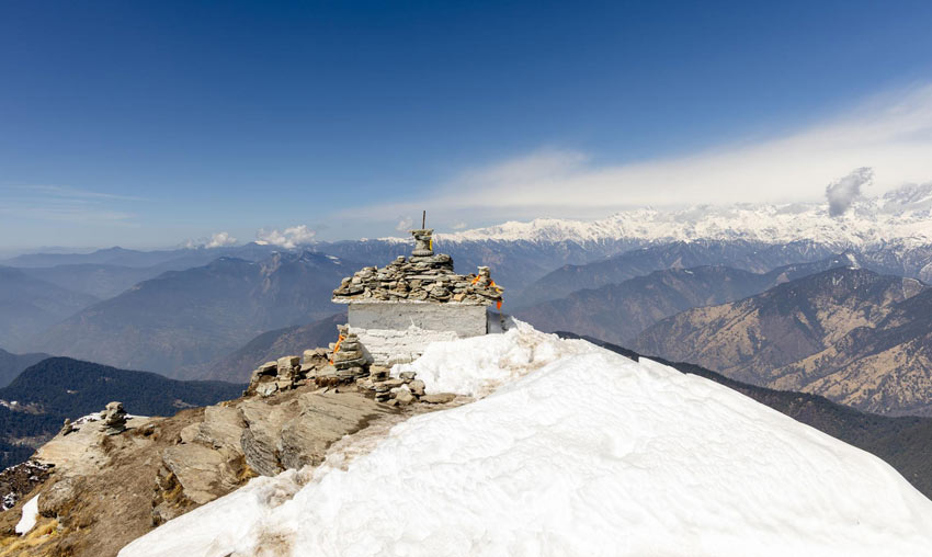
- Chandrashila Peak: A famous Himalayan summit offering panoramic views of snow-covered mountain ranges.
- Ukhimath: An important religious town associated with the winter worship traditions of Lord Kedarnath and Madhyamaheshwar.
- Sari Village: A traditional mountain settlement and the main starting point for the Deoria Tal trek.
Suggested Multi-Day Trekking Itinerary
Day 1 – Reach Sari Village and Trek to Deoria Tal
- Travel by road to Sari village.
- Prepare for the uphill trek and check local requirements.
- Walk through the forest trail towards Deoria Tal.
- Enjoy the lake and surrounding mountain scenery.
- Stay at an authorised accommodation or permitted campsite.
Day 2 – Deoria Tal to Syalmi via Rohini Bugyal
- Start early after breakfast.
- Follow the forest trail beyond Deoria Tal.
- Explore the rhododendron and maple forest sections.
- Pass through Rohini Bugyal and enjoy the meadow scenery.
- Continue towards Syalmi and reach the planned overnight stop.
Day 3 – Syalmi to Baniya Kund
- Continue along the trekking route towards Baniya Kund.
- Explore the forested mountain landscape.
- Reach the overnight stop and prepare for the next section.
Day 4 – Baniya Kund to Tungnath and Chandrashila
- Continue towards Chopta and the Tungnath trekking route as per the selected itinerary.
- Visit Tungnath Temple when it is open for worship.
- If weather and trail conditions permit, continue towards Chandrashila Peak.
- Complete the trek and arrange onward transport.
This is an indicative multi-day route based on the Deoria Tal–Chandrashila trekking circuit. Actual stages, camping locations and distances should be confirmed with the trek operator or local authorities before departure.
Travel Tips for Visiting Rohini Bugyal
- Plan the visit as part of a longer trek rather than expecting direct road access.
- Confirm the route, current trail conditions and forest permissions before starting.
- Wear sturdy trekking shoes with good grip.
- Carry warm layers and rain protection, even during summer.
- Carry sufficient drinking water, food and essential medicines for the trekking section.
- Use an experienced local guide if you are unfamiliar with the forest route.
- Do not attempt the trek during heavy rainfall, poor visibility or unsafe weather.
- Confirm authorised camping locations before planning an overnight stay.
- Do not pick rhododendron flowers or damage forest vegetation.
- Avoid loud music and do not disturb wildlife.
- Carry all waste back and keep the meadow and forest clean.
- Inform someone about your trekking route and expected return time.
Frequently Asked Questions About Rohini Bugyal
1. Where is Rohini Bugyal located?
Rohini Bugyal is located in the Chopta region of Rudraprayag district, Uttarakhand, along the trekking route from Deoria Tal towards Syalmi.
2. What is Rohini Bugyal famous for?
Rohini Bugyal is famous for its beautiful Himalayan meadow, rhododendron and maple forests, mountain scenery, birdwatching and trekking opportunities.
3. How can I reach Rohini Bugyal?
The meadow can be reached on foot through the trekking route from Deoria Tal towards Syalmi. Sari village is the main road-accessible starting point for the Deoria Tal trek.
4. Is there a direct road to Rohini Bugyal?
No. Rohini Bugyal is not directly accessible by motorable road. Visitors need to trek through the forest route to reach the meadow.
5. What is the best time to visit Rohini Bugyal?
March to June and September to October are attractive periods for exploring the region, depending on weather and trail conditions. March and April are particularly interesting for rhododendron flowers.
6. Can visitors camp at Rohini Bugyal?
Camping permissions and designated locations depend on current forest regulations. Visitors should confirm the rules with the Forest Department or an authorised local trekking operator before planning an overnight stay.
7. Is Rohini Bugyal part of the Deoria Tal–Chandrashila trek?
Yes. Uttarakhand Tourism includes Rohini Bugyal on the Deoria Tal to Syalmi trekking section of the Deoria Tal–Chandrashila route.
8. What is the distance from Deoria Tal to Syalmi via Rohini Bugyal?
The complete Deoria Tal–Syalmi trekking section via Rohini Bugyal is approximately 10 kilometres according to the Uttarakhand Tourism itinerary.
9. Is Rohini Bugyal suitable for beginners?
The meadow can be visited by beginners who have reasonable fitness and are accompanied by suitable local guidance. However, the longer Deoria Tal–Syalmi route requires preparation and should not be treated as a short casual walk.
10. Can Rohini Bugyal be visited along with Chopta?
Yes. Rohini Bugyal is part of the wider trekking circuit connecting Deoria Tal, Syalmi and the Chopta region. It can be included in a multi-day trekking itinerary.
Rohini Bugyal is a beautiful and peaceful Himalayan meadow in the Chopta region of Uttarakhand. Surrounded by rhododendron and maple forests, it offers a refreshing combination of open landscapes, mountain views and natural beauty.
Its location on the Deoria Tal–Chandrashila trekking route makes it an interesting destination for trekkers who want to explore more than the usual tourist attractions of the Garhwal Himalayas.
Whether you are interested in forest walks, seasonal flowers, birdwatching or multi-day Himalayan trekking, Rohini Bugyal is a wonderful place to discover the quieter side of Uttarakhand.
Nearby Places to Visit