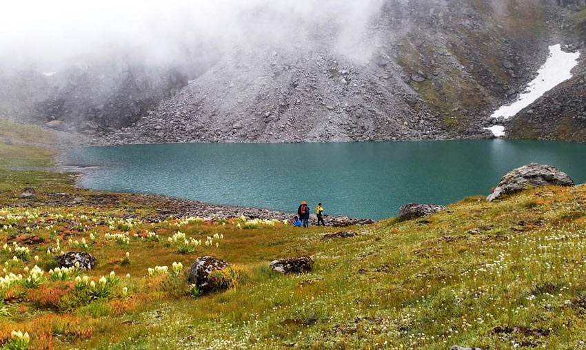
Nandikund Lake, Uttarakhand – Explore a Sacred Himalayan Lake
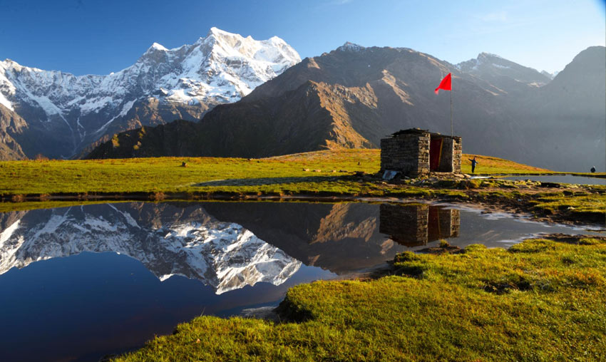
Hidden high in the Garhwal Himalayas of Uttarakhand, Nandikund Lake is a remote alpine lake known for its untouched natural beauty, spiritual associations and challenging trekking routes. Surrounded by green meadows, rugged mountain terrain and snow-covered Himalayan peaks, it is an extraordinary destination for experienced trekkers and nature enthusiasts.
Located in the wider Madhyamaheshwar region, Nandikund is associated with the high-altitude trekking route connecting the Madhyamaheshwar area with the remote mountain valleys of Garhwal. The lake is surrounded by the impressive Chaukhamba group of peaks and Mandani Parbat, creating a spectacular Himalayan setting.
Unlike easily accessible tourist lakes, reaching Nandikund requires a demanding trekking expedition. Steep climbs, descents, narrow ridges and remote trail sections make proper preparation essential. Its peaceful surroundings and dramatic scenery reward those who undertake the journey responsibly.
Where Is Nandikund Lake Located?
Nandikund is a high-altitude lake in the Garhwal Himalayas of Uttarakhand. It is associated with the Madhyamaheshwar region and the remote trekking landscapes around the Chaukhamba mountain group.
Government wetland records list Nandi Kund at approximately 4,369 metres above sea level. Some tourism sources publish different altitude figures, so the elevation should be treated as approximate.
The lake is located in a remote mountain area rather than beside a motorable road. Trekkers generally approach it through a longer Himalayan trekking route connected with Madhyamaheshwar and the wider Garhwal mountain region.
Why Is Nandikund Lake Famous?
Nandikund is famous for its high-altitude setting, alpine landscape and difficult trekking approaches. The lake is surrounded by green meadows, rugged ridges and snow-covered peaks, making it a memorable destination for experienced Himalayan trekkers.
It also holds spiritual significance in local traditions. The name Nandikund is associated with Nandi, the sacred bull and vehicle of Lord Shiva. The lake is regarded by many pilgrims and local traditions as a sacred natural site.
Its remote location, natural beauty and connection with the Madhyamaheshwar region make it one of the lesser-visited high-altitude destinations in Uttarakhand.
Natural Beauty of Nandikund Lake
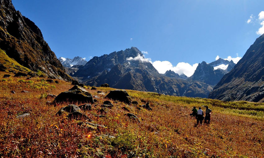
The landscape around Nandikund changes as trekkers gain altitude. Forested mountain slopes gradually give way to open alpine meadows, rocky terrain and high-altitude landscapes.
The lake lies amid a dramatic Himalayan setting, with the Chaukhamba group and Mandani Parbat forming important features of the surrounding mountain scenery. During suitable weather, the clear water and mountain environment create beautiful opportunities for landscape photography.
The region is also valued for its alpine vegetation and relatively undisturbed natural environment. Visitors should take care not to damage fragile meadow plants or disturb wildlife.
Altitude of Nandikund Lake
According to government wetland inventory information, Nandikund is recorded at approximately 4,369 metres above sea level. Other tourism sources mention higher figures, so published elevations are not fully consistent.
At this altitude, trekkers can experience low temperatures, rapidly changing weather and a greater risk of altitude-related illness. Proper acclimatisation and a cautious trekking plan are essential.
Nandikund Lake Trek – Route, Distance and Difficulty
The Nandikund trek is a remote and demanding Himalayan expedition. One approach is connected with the Madhyamaheshwar trekking region, while longer routes also connect with the Urgam Valley and Kalpeshwar side.
The route is not a simple day hike. It involves multiple days of walking through mountain valleys, high-altitude meadows, steep ascents and descents. Certain sections may have narrow ridges or poorly defined trails.
Common Trekking Approach
A commonly described expedition route from the Madhyamaheshwar side follows this general sequence:
- Ransi Village: A commonly used starting point for the Madhyamaheshwar trekking route.
- Gaundar and Bantoli: Mountain settlements and trail sections along the approach.
- Madhyamaheshwar Temple: The sacred Panch Kedar shrine in the high-altitude valley.
- Kanchani Tal and Pandav Sera region: Remote high-altitude landscapes associated with longer trekking expeditions.
- Nandikund Lake: The destination in the alpine mountain region.
Some extended itineraries continue towards Ghiya Vinayak Pass and the Urgam Valley. Route conditions, access and itinerary details should be confirmed with experienced local expedition operators before departure.
Trek Difficulty
The Nandikund trek is considered difficult and is better suited to experienced trekkers. The high altitude, steep climbs, narrow ridges, remote terrain and limited facilities make it unsuitable for casual visitors or unprepared beginners.
Trekkers should travel with an experienced local guide or qualified expedition team, carry suitable equipment and allow enough time for acclimatisation.
Best Time to Visit Nandikund Lake
The best time for a Nandikund expedition is generally during suitable summer and post-monsoon trekking windows. Weather in the high Himalayas can change quickly, and the final decision to travel should depend on current snow, rainfall and trail conditions.
May to June
Late spring and early summer are commonly used for high-altitude trekking in the region. Snow conditions can still affect upper sections, and temperatures remain cold, particularly at night.
July to August
The monsoon brings heavy rainfall to Uttarakhand. Landslides, slippery trails, swollen streams and poor visibility can make remote trekking dangerous. Avoid attempting the expedition during periods of heavy rain.
September to October
Post-monsoon months can offer clearer mountain views and relatively stable trekking conditions. However, temperatures fall quickly at high altitude, and early snowfall can affect the route.
November to April
Winter brings severe cold and heavy snowfall to the high-altitude region. The route may become inaccessible or extremely hazardous. Do not plan a winter visit without current local guidance and appropriate expedition support.
How to Reach Nandikund Lake
By Air
Jolly Grant Airport near Dehradun is the nearest major airport commonly used for travel to the Garhwal region. From the airport, visitors must continue by road towards Rudraprayag, Ukhimath and the relevant trekking approach.
By Train
Rishikesh is a major railway access point for travellers heading towards the Garhwal Himalayas. From Rishikesh, visitors can continue by road towards Rudraprayag and Ukhimath.
By Road
Ukhimath and the surrounding Rudraprayag region are connected by road to major towns in Uttarakhand. The road journey continues towards the selected trekking starting point, depending on the route and current access conditions.
Read more: Ukhimath Travel Guide.
By Trek
The final approach to Nandikund is completed on foot. The Madhyamaheshwar side is one of the commonly described approaches, but it involves a longer expedition through remote high-altitude terrain. There is no direct motorable road to the lake.
Places to Visit Near Nandikund Lake
1. Madhyamaheshwar Temple
Madhyamaheshwar Temple is one of the sacred Panch Kedar shrines dedicated to Lord Shiva. Located in a beautiful Himalayan valley, it is an important religious destination and a key point on the trekking approach associated with Nandikund.
Read more: Madhyamaheshwar Temple Travel Guide.
2. Budha Madhyamaheshwar
Budha Madhyamaheshwar is a small sacred shrine located approximately 2 km uphill from the main Madhyamaheshwar Temple. It is known for its beautiful mountain views and peaceful surroundings.
Read more: Budha Madhyamaheshwar Travel Guide.
3. Kanchani Tal
Kanchani Tal is another high-altitude lake in the wider Madhyamaheshwar region. It is reached by a strenuous mountain trek and is associated with longer trekking expeditions towards Nandikund.
4. Pandav Sera
Pandav Sera is a remote mountain meadow region associated with trekking routes in the upper Garhwal Himalayas. It is known for open landscapes and its traditional connection with the Pandavas in local folklore.
5. Ukhimath
Ukhimath is an important religious town in Rudraprayag district and a convenient regional base for journeys towards Madhyamaheshwar. It is famous for Omkareshwar Temple, the winter seat of Lord Kedarnath.
Read more: Ukhimath Travel Guide.
Things to Do at Nandikund Lake
- Enjoy Himalayan scenery: Admire the surrounding mountain peaks and high-altitude landscapes.
- Experience remote trekking: Explore a challenging route through alpine meadows and rugged terrain.
- Photography: Capture the lake, mountain ridges and natural surroundings.
- Explore alpine meadows: Observe the fragile vegetation and changing mountain landscape.
- Experience spiritual tranquillity: Appreciate the traditional religious associations of the lake.
- Responsible nature travel: Explore the region while protecting its sensitive Himalayan environment.
Accommodation and Facilities
Nandikund is a remote high-altitude destination without regular hotel or resort facilities beside the lake. Trekkers should not expect permanent accommodation, restaurants, shops or medical facilities along the upper route.
Expedition teams generally plan overnight camping and carry the equipment and supplies required for the journey. Any camping arrangements should follow local rules, environmental guidelines and permissions where applicable.
Arrange accommodation in road-accessible villages before starting the trek. Confirm the availability of local guides, porters and support staff well in advance.
Important Travel Tips for Nandikund Trek
- Attempt the trek only if you have suitable high-altitude trekking experience and fitness.
- Hire an experienced local guide or qualified expedition operator.
- Allow adequate time for acclimatisation before gaining significant altitude.
- Carry proper trekking boots, warm layers, waterproof clothing and a suitable sleeping system.
- Carry sufficient food, water-treatment supplies and essential medicines.
- Check weather forecasts, trail conditions and local permissions before departure.
- Do not attempt the route alone or without a reliable navigation and emergency plan.
- Be prepared for limited mobile network coverage and limited rescue access.
- Never leave plastic, food wrappers or other waste in the mountains.
- Do not enter the lake or disturb the natural surroundings.
- If symptoms of altitude sickness develop, stop ascending and seek prompt medical assistance.
Frequently Asked Questions About Nandikund Lake
1. Where is Nandikund Lake located?
Nandikund is a high-altitude lake in the Garhwal Himalayas of Uttarakhand, associated with the Madhyamaheshwar region and remote trekking routes.
2. What is the altitude of Nandikund Lake?
Government wetland records list Nandikund at approximately 4,369 metres above sea level. Other sources publish different figures, so the elevation should be treated as approximate.
3. Why is Nandikund Lake famous?
Nandikund is known for its remote Himalayan setting, alpine meadows, mountain scenery, challenging trekking routes and spiritual associations with Nandi.
4. Is the Nandikund trek difficult?
Yes. It is a difficult high-altitude expedition involving steep climbs, descents, narrow ridges and remote trail sections. It is better suited to experienced trekkers.
5. Can beginners visit Nandikund Lake?
The trek is not recommended for unprepared beginners. Anyone considering the journey should have suitable fitness, high-altitude preparation and support from an experienced expedition team.
6. What is the best time to visit Nandikund?
May to June and September to October are commonly considered suitable trekking windows, subject to snow, rainfall and current trail conditions.
7. Is accommodation available near Nandikund Lake?
There are no regular hotel facilities beside the lake. Trekkers generally need to plan a supported camping expedition and carry the necessary equipment and supplies.
8. Can Nandikund be visited from Madhyamaheshwar?
Yes. A trekking approach from the Madhyamaheshwar region is described in trekking routes. However, it is a longer expedition through remote terrain and should not be treated as a short day hike.
Nandikund Lake is one of the remote natural treasures of the Garhwal Himalayas. Its high-altitude setting, alpine meadows, dramatic mountain views and spiritual associations make it a remarkable destination for experienced trekkers seeking a challenging Himalayan expedition.
The journey requires careful planning, suitable equipment, acclimatisation and experienced local support. Visitors who travel responsibly can experience the remarkable beauty of this remote region while helping preserve its fragile mountain environment.
Nearby Places to Visit